Tag Archives: Nuclear Disaster

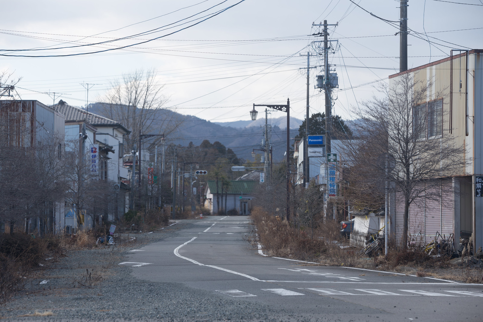
After the Japanese Disaster and into the Fukushima Exclusion Zone

Last week I traveled with Japanese advertising director and photographer Yohei Morita through Tōhoku, the Japanese region critically affected by the March 11, 2011 earthquake, tsunami, and subsequent nuclear disaster.

Tōhoku is wedged between the Sea of Japan and the Pacific Ocean on the northern portion of the country’s largest island, Honshu. Compared to southern Honshu and its major cities, the region is rural and less habitable, even along the coastlines. The island’s volcanic and tectonic history are clear there, where the coastal hills make way for the Ōu Mountains and its national parks, hot springs and temples, including the famous Yama-dera temple complex that dates back to the ninth century.

Yama-dera Temple Complex
Yama-dera

The landscape that makes the coastal regions of Tōhoku so lovely amplified the disaster. While most of the region escaped unscathed, along the eastern section of the coast, the mountains and hills make way for the dozens of small bays and river valleys that became the locations of small towns. For hundreds of years, residents of these towns lived side-by-side with their rice paddies and fishing fleet harbors, and the hills above were the locations of shrines and timber harvesting. When the tsunami struck, it rose as high as 130 feet, immediately overwhelming many eastern coastal harbors and surging up the rivers, which jumped their banks and flood-walls. Whole towns were nearly destroyed. The Japanese government estimates that more than 18,000 people lost their lives, and another 340,000 were displaced.

Building on its Side
Building on its Side, Onagawa

Towns and business that were farther inland quickly became safe harbors for the residents who survived. Among others is Oiwake Onsen, a traditional spring inn near the nearly submerged town of Onagawa, which became the home for two dozen elderly town residents. They lived in the inn for nearly six months while the cleanup and rebuilding occurred.

IMG_7209 Onsen
Oiwake Onsen

Nearly three years since the disaster, many of these towns have been cleared of most debris and now resemble fallow fields. Where new buildings do dot the landscape, they are typically prefabricated structures or even converted shipping containers. While driving along the coastal roads, we would often emerge from the hills to find a cemetery on the edge of the field. It replaced the town. Survivors have also constructed shrines near the disaster sites, including the Okawa primary school where 74 children and 10 teachers perished when the surge breached the river banks 30 minutes after the earthquake.

Ogatsucho Mizuhama
Ogatsucho Mizuhama

Ishinomaki by the Ocean
The Coast of Ishinomaki

Cemetery Along the Kitakami River

Christmas Tree and Memorial, Ogatsucho Kamiogatsu

Okawa Elementary School and Temporary Memorial
Temporary Memorial Outside Okawa Elementary School

Few of those residents who survived the disaster have returned home. Some live in nearby resettlement camps that are safely placed in the hills. Many have left the rural areas for regional cities like Sendai City or Ishinomaki, but others have left for Japan’s metropolises, including Tokyo and Kobe.

Resettlement Housing
New 23 Unit Housing Complex Outside Onagawa

Instead of houses, construction work fills the area. Whole fleets of trucks are at work removing debris and moving the earth to fortify embankments, build roads and prepare other kinds of infrastructure. This construction work provides one new source of regional employment, including for unskilled labor like the sweepers that flank each site. Rebuilt fishing harbors are being put to limited use, and timber and oyster production is scaling up. Tourism is even increasing in the region, like at the Zuiganji temple and the nearby Matsushima Bay. Still, even major towns like Ishinomaki — which celebrated removing all disaster debris on the day we arrived — are suffering from economic conditions beyond the direct effects of the tsunami and earthquake.


Trucks Along the River
Trucks Waiting for a Stoplight Along the Kitakami River

Rebuilding a Road and River Barrier
Rebuilding a Road and Kitakami River Barrier

IMG_7287_8 Shellfish Production
Lumber and Shellfish Production in Miyagi Prefecture

Quiet Arcade Street in Ishinomaki

Ishinomaki
Ishinomaki from Above, with Reconstruction Underway

Zuiganji Temple
Zuiganji Temple Grounds

Despite all of this activity, one area remains nearly as it was on the day of the earthquake: the Fukushima Daiichi nuclear power plant exclusion zone. One of two nuclear power plants along the Fukushima Prefecture coastline, the Fukushima Daiichi plant was compromised by the tsunami and suffered catastrophic failures over the following few days. The explosions and other problems led to the release of radioactive material into the air and ocean. The Japanese government instituted a mandatory evacuation for residents in a 20km and then 30km radius; however, the evacuation zones were initially designed to protect against contamination from an explosion, rather than the distribution of radioactive material through wind and other weather patterns. The result was many residents were exposed to radioactivity despite the government response. Those in the areas to the northwest of the plant — even those outside of the exclusion zone — suffered the highest contamination, although radioactive hotspots are located over northern and central Honshu, including in Tokyo. Still, the government is quick to point out that the amount of radiation released was considerably less than that at Chernobyl, and scientists currently anticipate only slight increases in cancer rates among most of those exposed. We can hope.

Today, several towns within the exclusion zone remain evacuated. They are primarily frozen in time, ghost towns that — until very recently — were left as they were three years earlier. Emergency crews are removing radioactive material and have removed some debris from the streets, but nearly everything else is as it was on the day of the disaster. Cars are upturned, houses are open and plants sprout everywhere.

Thanks to Deputy Mayor Hirofumi Sanpei, we visited the small town of Tomioka that sits on the edge of the exclusion zone and is still closed to the general public. It had a population of more than 16,000 before the disaster and is located next to the other nuclear power plant in the region, the Fukushima Daini Nuclear Power Plant. Just beyond its boundaries is the former J-Village national soccer complex that is the major staging area for the recovery effort.


Deputy Mayor Hirofumi Sanpei
Deputy Mayor Hirofumi Sanpei Indicates Where We Will Travel

Upturned Cars, Downtown Tomioka

Downtown Tomioka
Downtown Tomioka Street

Shop Window
Downtown Tomioka Shop Window

Downtown Tomioka
Downtown Tomioka Street

Downtown Tomioka Shop
Downtown Tomioka Shop, Clock Stopped at the Time the Earthquake Struck: 2:46pm

Memorial Flowers
Memorial Flowers by the Main Tomioka Train Station

The town itself remains blanketed in low levels of radiation. Official radiation monitors are exclamation points in the landscape, announcing the immediate radioactivity readings in microsieverts (μSv) per hour. The areas we visited ranged between 0.07 μSv in the mountains to 4.5 μSv near one of the town’s former train stations. My personal monitor was generally between 0.2 μSv and 0.7 μSv. [For more data about radiation in the Fukushima disaster area, visit Safe Cast or this national map display.]

To put the readings into perspective, the United States Environmental Protection Agency estimates that a chest x-ray contains between 20-50 μSv, and radiation exposure on a cross-country flight is as much as 50 μSv. In other words, I experienced more radiation during my flight to Japan than in the few hours I was in the exclusion zone, although the kinds of radiation I experienced near Fukushima were more likely to be absorbed. To reduce the amount of absorption, I wore some protective clothing, a mask to avoid inhaling contaminated dust on a windy day, and shoe coverings, which were provided by and tested for radioactivity by Tokyo Electric Power Co. when we left the region. They were “clean.”


Radioactivity Monitor, Closed Section of Tomioka
Radioactivity Monitor in Tomioka Reading 4.119μSv per hour

While the general public is not permitted to access the town, most residents have been recently allowed to return to survey damage to their property, although they are not permitted to move back into their homes. The delay is partly caused by the radiation and partly caused by infrastructure problems. The result is that most of the town remains eerily quiet, even though a massive recovery effort is underway.

The most visible signs of the recovery effort are the construction vehicles on the main roads, the large piles of bags of contaminated soil, and the white plastic of temporary roof repairs. Still, some areas of higher contamination are off-limits even to the town’s residents. The blockades are visible on GPS systems, and officers working road checkpoints require official government permission to enter. Beyond these areas, the evidence of the earthquake is clearer and few repairs have occurred.

Roadblocks on GPS Roadblock in Tomioka
Roadblocks in Tomioka

Workers, Tomioka
Workers, Truck Moving Soil in Tomioka

Abandoned Yonomori Train Station
Abandoned Yonomori Train Station in Tomioka’s Heightened Exclusion Zone

Street in the Heightened Exclusion Zone
Street in Tomioka’s Heightened Exclusion Zone

Bagged Radioactive Debris
Bagged Radioactive Debris Outside of Tomioka

After we left the area, we headed into the mountains to the village of Kawauchi. The village was affected by the earthquake but was the immediate destination for Tomioka residents fleeing the tsunami. As many as 6,000 residents jammed the scenic mountain road and tunnels that lead to the town and were then housed in schools and other sites. All were then evacuated from Kawauchi when the nuclear evacuation order was executed.

Significantly fewer residents live in the town since the evacuation order was lifted on April 1, 2012. Two of the three elementary schools have closed, and only a handful of students remain in each grade. The radiation levels in the town were the lowest we experienced in the region, at only 0.07 μSv. Area residents are tentatively optimistic about the area’s long-term prospects, but the future is unclear for this town and many others in the region.


Kawauchi Street
A Kawauchi Main Street

Kawauchi Elementary School Class

The entire eastern coast is working its way to recovery, but it will take generations assess the total cost of the great Tōhoku disaster. Officials continue to grapple with containment issues at the Fukushima Daiichi Nuclear Power Plant, and residents and government agents continue to scale up the recovery effort. At present, the government estimates it will re-open Tomioka by 2017, although there are questions about who will return. Nuclear energy and tsunami and earthquake preparedness are being discussed around the country, where even the Tokyo governor race is becoming a de facto referendum on the government nuclear response. Japan’s nuclear future may hang in the balance.

Special thanks go to Yohei Morita and Tomioka Deputy Mayor Hirofumi Sanpei, whose assistance was essential to producing this essay.