Category Archives: Text

The United States Steel South Works

There’s been a renewed interest in the site of the former United States Steel South Works following Dave Matthews Band Caravan‘s use of the area. Thinking readers might enjoy a little history of the site, I’ve edited a few excerpts from my master’s thesis on the development (and decline) of the site and posted them here along with some supporting materials.

Development of USS South Works Site, 1869-2003

Compiled and aligned maps from USGS, Department of War, USS and other sources

In the mid-1800s, Chicago’s iron foundries were located on the north side of the Chicago River, but as the city expanded and demand for metal products boomed, iron and steelmakers sought space to spread out. While some business moved north, many eventually made their way to the Calumet area, which was not incorporated as a part of southeastern Chicago until the late 1880s. Businesses moved south in part due to the efforts of the Calumet Canal and Dock Company, which promoted the region as near industrial paradise. Claimed benefits of the region included lower taxes, access to rail and water traffic, and recent improvements by the Army Corps of Engineers. Among those companies lured were Pullman, which created the town of Pullman in 1881, and the North Chicago Rolling Mill Company, which bought the future site of the South Works in 1880.

The North Chicago Rolling Mill Company was founded in 1857 by Captain E.B. Ward to satisfy demand for railroad rails that was fueled by western expansion and a general boom in railroad construction. The company came to prominence in 1865 as the first company to roll steel rails rather than the much less durable iron rails. Despite a number of improvements to the North Works, Orrin W. Potter, President of the Rolling Mill Company, and other business partners realized that the North Works was too cramped to meet ballooning demand for steel rails. As such, they needed to create another works, so on March 28, 1880, the Rolling Mill Company bought 73 acres of land with 1,500 feet of frontage on the Calumet River and 2,500 feet on Lake Michigan and broke ground for what would become the first integrated rail mill in the world.

After acquisition of the marsh and beach land, the Rolling Mill Company began adding to the littoral transport of sediment that was trapped by the new government “improvements” with “great quantities of slag and refuse from their mills, on the shore and in the lake along it thereby artificially increasing the natural advance of the shore line.” By 1882, more than 30 acres of land had been added to the site.

This was the beginning of a long phase of expansions of the site that was conducted by a variety of owners, including United States Steel, until the late 1920s. Over the years, hot slag, granulated cinders and dirt were slowly poured into the site using small railroad cars. The location of the types of deposits is only partially known. Records of the deposits were regularly collected and noted by the site owners, but (at least surviving) maps were not cumulative for the process, so only spotty records of the types and times of fill exist.


Infill, 1919
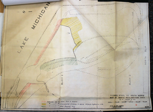
An Illinois Steel Company map showing infill on the north end of the “reclamation” area, 1919

Crib Wall
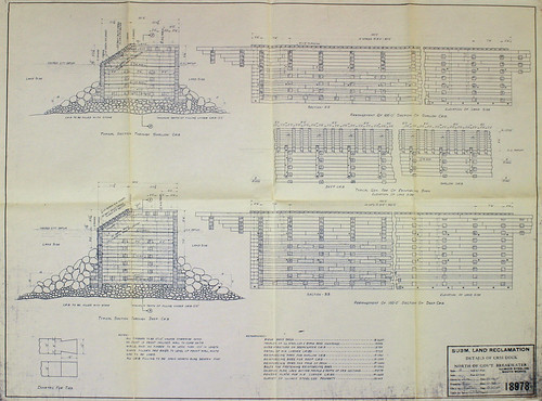
Detail of a crib wall used during the infill process, 1914

By 1933, USS had completed infill activities and had nearly saturated the now 576 acre site with buildings without establishing a coherent plan for expansion. While the South Works would operate for another sixty years, this design problem would be a major factor in its undoing. While an attempt to “reclaim” an additional 194 acres from Lake Michigan was floated in 1963, the expansion was never made, and investments became increasingly sporadic as the global steel trade underwent extreme changes.

By the early 1980s, plant closure was certain after a major planned expansion was cancelled. Within 22 years starting in 1970, the Works changed from a major steel operation with a rated annual steel capacity of over seven million tons and more than 10,000 employees to a plant with a capacity of only 44,000 tons and 690 employees at its closing in April 1992. Massive demolitions were well underway.

1983 to 1994
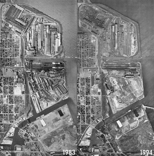
USGS aerial photographs of the South Works from 1983 and 1994 showing massive demolition of site structures

After closure, the site continued to be fiscally productive for the company through slip leasing, utility negotiations and other activities, but it slowly gained its derelict appearance despite EPA activities, the proposed Solo Cup plant and the park service expansion along the coast.

United States Steel South Works Ore Bin Panorama
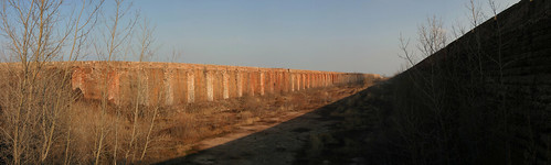
Looking into the north ore bins, 2003

Today, the most prominent structures are the ore bin walls, which have massive holes in them from the crane removal process. Wildlife has thrived in the interiors of these ore bins, with the concrete pad providing easy development of a wetlands and many of the supporting flora and fauna. When walking the site in 2003 and 2004, I saw or saw evidence of animals as diverse as horned owls, deer and foxes.

USS has experimented various plans for the site over the last twenty years with little luck, although it looks like the USS/McCaffery Interests current development plan may be realized in some capacity. Whether the development looks anything like the current proposal is anybody’s guess.

South Works Development Pitch
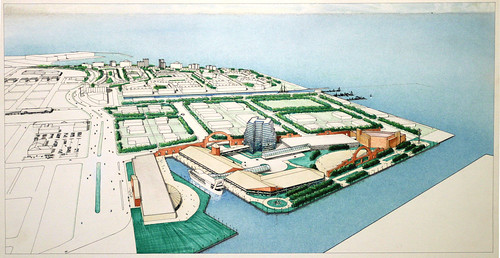
A previous development plan


The current promotional video for redevelopment

    Let me know if you’d like a citation for any of this material. The records of USS, the EPA and a variety of local historical societies were helpful in defining the history outlined above. Additionally, Kenneth Warren’s Big Steel: The First Century of the United States Steel Corporation, 1901-2001 and trade publications from the day were invaluable.

Vancouver, British Columbia

I just returned from a trip to Vancouver, British Columbia for the International Visual Sociology Association‘s annual meeting. While there, I had an opportunity to learn more about Vancouver’s Downtown Eastside thanks to Naomi Bartz, Kelly Nairn and some of my own exploring. The area is the location of a major redevelopment effort, particularly in regards to its high number of boarding houses and SROs. If you’re interested in learning more about the area and its housing issues, the City of Vancouver Social Development Department has several interesting reports, including this section on the Single Room Accommodation By-law.

Below, the first image is of the neighborhood’s new mixed-income Woodward’s redevelopment, complete with its staged photograph of the Gastown Riots. A few images of the Downtown Eastside SROs (and the clubs on their first floors) follow, after which I’ve included a few of my favorite images from throughout the city. As always, you can view more of my photographs from the trip on flickr.


Inside the Woodward's Redevelopment, Stan Douglas's

Vancouver's Favorite Country Music Pub (and SRO)

Looking East on Hastings

Regent Hotel, Union Market, Hastings Street

Brandiz

Other Vancouver Photographs


Hedge

Safeway

Military Housing

Vancouver Tunnel Skate Park

Save-On Meats

Entrance

Albuquerque, New Mexico and Pajarito Mesa

Last week I flew to New Mexico to attend the amazing Review Santa Fe (about which I may write later), and I was fortunate enough to be able to spend a day in Albuquerque before heading northeast. The highlight of my brief visit to Albuquerque was spending a little time in a colonia to the southwest of town on the Pajarito Mesa.

Due to a variety of legal issues, the 400 family colonia has no public utilities, including running water, electricity or direct access to school busing for children. Despite this immigrant community living on the mesa for approximately 25 years, it only recently received a well to fill portable water tanks. Residents previously had to drive several miles off of the mesa for potable water. The new well offers 1,000 gallons of water for $10.

Additional information about the community can be found here. A few of my photographs of the area are immediately below, followed by others from Albuquerque and its edges.

Warning: Purchasing Property on the Pajarito Mesa May be Illegal

Filling the Water Tank

Colonia Pajarito Mesa

Entrance

Albuquerque, New Mexico

Residential Building

In the Dust, Out West

In the Dairy Lot

Swamp Cooler Service

A Road Through the Scrap Piles

Mt. Calvary Cemetery

As always, additional images are available on flickr.

Dallas, Texas and Tushka, Oklahoma

I recently spent a few days in Dallas, Texas and a half day in Tushka, Oklahoma, which is steadily rebuilding after being struck by a tornado in April. The tornado clean up provided a clear focus to my southern Oklahoma images, while my Dallas images were primarily trained on its near southern and western sides of the city. A selection of my images from the region is below.

As always, you can see additional images from Dallas and Tushka and its surroundings on flickr.

Dallas, Texas

Texas Paint & Wallpaper

3338

Along the Water

Elmers Drive-In, Downtown Dallas

The Horse

Asleep

Laredo Muffler & Radiator

Rays

Big Daddy's Liquor Beer Wine

Tushka, Oklahoma

SBA Disaster Assistance, Damaged Commercial Property

Family Room

Main and Oklahoma

Tornado Shelter, Cleanup at the School

Burning Post-Tornado Debris

Swingset, Debris Pile

Preparing the Chairs

New Orleans, Louisiana

I’ve just returned from a few days in New Orleans attending the Society of Architectural Historians‘ annual meeting and visiting field sites. In my spare time, I photographed other portions of the city, from which a selection is posted below. If you’d like to see more, a variety of other images from 2010 and 2011 are posted in my New Orleans set on flickr.

Walking, Cemetery

New Orleans Central Business District in the Late Afternoon

Thou Shalt not Kill

Sitting Woman, Restaurant Signage, Defunct Pay Phone

Residential Buildings, Boys on Bicycle, Falstaff

Cutting Hair at Public Enemy Cuts

Before I die...

Don't Kill Our People

Rehabilitation, Dixie Beer

Rims & Tire Services Before Sunrise

Topeka and Kansas City

I just returned from a visit to Topeka, Kansas and Kansas City (Kansas and Missouri), where I conducted some interviews, visited with good people and, of course, photographed. While I came down with a cold in Kansas City, I was still able to do a little shooting in both locales. Some of my favorite images from the trip are below.

Kansas City, Kansas and Kansas City, Missouri

Kansas City

Railroad Tracks, Grain Elevator, Skyline

Three

Inner City Oil Co. Inc.

Exhaust

Peace in the Hood, Paz en el Barrio

Basketball Court

Topeka, Kansas

Hanover Pancake House, McDonald's, Water Tower

Used Car Sales

North Topeka Intersection

Shoveling Snow Outside Bradley's Corner Cafe

Beneath I-70

517, Railyard

McAbee Body Shop in the Snow Storm

Transitions Between Here and There

My interest in the transformation of the built environment started with watching the razing of central Indiana farmsteads for suburban expansion in the early 1990s. These buildings, like the one below, became the subjects of my first landscape photographs.

Hamilton County, Indiana, 1994

While I typically work in urban areas now, I make an effort to spend time in the rural and transitional areas between Indianapolis and Chicago whenever I have occasion to leave the city.

Many of the same issues affect these areas as they did when I was learning about them in the early 1990s, but the region is more complex than it was then. Even with the recent recession, the rural edges are still pressured by suburban expansion, but a variety of other economic and geographic pressures demonstrate the changing rural landscape.

The area is dotted with vestiges of commerce, from familiar billboards and grain elevators to new forms of industry, including wind turbines and industrial agriculture property. Together, they introduce new pressures on longstanding concerns about exurban development while providing some hope against outmigration in truly rural communities.

With those brief thoughts as background, here are a few of my favorite photographs of the places between my former and current homes.

Indiana Hub Center Remington

Agribusiness at Night 3

Christmas Eve

Eagle Creek Cemetery

Stand

A New Rural Landscape

Otterbein Town Square

Sheridan, Christmas Eve

The Fowler Theatre

Basketball in Lebanon, Indiana

Transition: Suburban Development and Farm

Kyburz Auto Center Stage, Wind Turbines

Twin Kiss

Grain Elevator, Mobile Home

At Night

A Year of Photographing Elsewhere

There’s no question that 2010 was an unprecedented year for my fieldwork. In addition to many Chicago area opportunities, I visited nearly two dozen major U.S. cities and had the opportunity to spend time in Belfast, Northern Ireland during Twelfth Night. Each location allowed for several days in the field, so I’ve amassed quite a collection of photographs.

As a way of getting a handle on that work, I pulled out one favorite photograph from many of the locations I visited. A few were exhibited in my recent work shows at the Op Shop and Everyblock, as well as the “Considering the City” show at Work • Detroit, but one would have to consistently follow my flickr stream to see all of these images — so I thought I should share them here.

Atlanta, Georgia

Walking

Baltimore, Maryland

Perlman Place, Baltimore

Belfast, Northern Ireland

Belfast Loyalist Bonfire Preparation, View #1

Chicago, Illinois

Residential Building, New Lights

Clinton, Iowa

Detroit, Michigan

Lit Sides

Indianapolis, Indiana

Skip's MARKET

Las Vegas, Nevada

Police Raid, Children Walking

Milwaukee, Wisconsin

Running Through the Demolition Site

New Orleans, Louisiana

Davis Mortuary Service, Crescent City Connection

New York City, New York

Metal Recycling, Cooperative Housing, Bronx

Oakland, California

In the Glow

Phoenix, Arizona

Sunnyslope Mountain, Women Talking

San Francisco, California

Repairing

Sparta, Georgia

Hancock County Court

Washington, D.C.

Memorial, Anacostia Public Housing